|
About the Weather Site and the Placerville, California Area
With cold wintry days, beautiful fall colors, verdant springs and very warm and hot summer days. One of the benefits of living at this elevation in the Sierra Nevada Foothills in California is that it's typically below the snow level. That means no snow shoveling! Placerville usually gets a dusting of snow a couple of times a year. Snowfall amounts of 2 to 4 inches can and do occasionally occur however.
Placerville can get some very strange weather on rare occasions. A couple of those weather incidences come to mind. I can remember like it was yesterday. In the winter season of 1989/1990 Placerville experienced a fluke snowfall event which left behind about 2 feet of snow in downtown Placerville. Cameron Park had a good foot to foot and a half of snow. It was quite the mess as the snow level was down to El Dorado Hills, and it was snowing in Folsom without being able to stick to the ground.
Several areas lost their electricity for a few weeks. So at times, although extremely rare, Placerville can receive a deep blanket of snow. It has been over 16 years since that last heavy snowfall event. A year later in the winter season of 1990/1991 Placerville had a nasty deep freeze. It stayed below freezing for about 2 weeks, with day time highs in the low to mid 20's. At night it hovered near zero! The pool in our backyard had a thick cover of ice. Thick enough to easily walk on, with a thickness of about 18 inches of ice. Pipes were breaking everywhere in the foothills down throughout the entire Sacramento Valley. Although rare, extreme weather has been known to happen here. You just never know.
For the rainfall season 2005/2006 the total rainfall for Placerville ending June 30th 2006, was 58.45 inches of rain. The average annual rainfall is 38.75 inches. This is just shy of 20 inches of rainfall higher than the normal yearly amount. Normally with this much rainfall in northern California, you would expect to see a lot of flooding problems in wide spread areas. Luckily the precipitation was extremely well spread out over the rainfall season. This made for a lot of cloud filled days, and thus a succession of rain filled days. Because the rainfall was so well spread out, it allowed the land to better keep up and soak it all in.
THE FREAK SNOW STORM of December 7, 2009 - Shortly after midnight it started to snow. I figured it would be just like other snows that left at the most just a inch or two on the ground. Around 3:00am I started to hear crackling noises outside my bedroom window. This made me extremely concerned because it was the sound of oak trees getting ready to snap from the heavy weight of the snow. Our home has huge oak trees all around the house with several of them hanging right over the roof.
I stayed up all night keeping watch on the danger. At first I thought it was just one oak tree getting ready to snap and making all of those crackling sounds. Finally a huge limb came crashing down that thankfully had missed the house, but when it fell, it made a huge whooshing sound as the wind and ice crystals hit my bedroom window hard. I was relieved because I thought the danger was finally over and the suspect tree had finally come down. Now I can get some sleep. I could not have been more wrong!
Then I start to hear those crackling noises again and soon realized that many trees and limbs were ready to come crashing down from the weight of all the snow. During the rest of the night tree after tree and limb after limb came crashing down. One hit the edge of the roof and thankfully did little damage. Another huge oak tree now resided in our swimming pool.
When the light of morning finally came after a long night with no sleep, I saw that there was at least a foot of snow on the ground with trees and huge limbs of trees laying everywhere. Since I have never lived anywhere that had snow, I really had no idea what can happen to trees from a heavy snow. I found out it's very common for trees and limbs to come crashing down from a good snow.
We had no electricity for 3 full days with very little firewood to keep us warm and cook our food. The entire neighborhood looked like a war zone with trees down everywhere including across many roads. It was a disaster area! Everyone had countless trees and limbs down! In the aftermath you could hear chainsaws close and in the far distance humming away for weeks as everyone was trying to clean up from the mess.
Although Placerville, California rarely gets more than a few inches of snow at a time, it is more than capable of getting freak snow storms with a foot of more of snow. These deep snow events seem to happen about once every 10 years of so.
|
The Weather Station & How We Take Our Weather Readings
This station is equipped with a 24-Hour Fan-Aspirated Radiation Shield for maximum accuracy. It has an internal fan in with the sensors that keep the air moving and stirred up for accurate temperatures & humidity readings. This weather station is solar powered with a backup battery back up to ensure complete and continuous reliability under all conditions. I am using a high powered dedicated server for the sole purpose of providing and uploading live weather data feeds to the Internet. This site also provides live lightning radar, current condition maps, web cam, and live streaming noaa weather radio stream emulating directly from the El Dorado Weather site.
All though our readings are very accurate, it should never be the sole source for weather related emergency data. You must never make important decisions based on this information or any weather information obtained over the Internet.

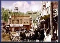
The photo on left is down town main street Placerville CA. (circa mid 1800's)
The weather data from all of our outdoor weather sensors at this station are sent to our computer server via a remote wireless connection. The data is then uploaded to the Internet. This process takes approximately 2 1/2 seconds from the data sensors, to the computer, to be being posted on the internet, which essentially gives you live, real time weather data as it is happening live.
The El Dorado County, Placerville California Weather Station measures, current temperatures, humidity, dew point, "daily, weekly, monthly, and yearly rainfall", barometric pressure, wind speed & direction, & wind gusts, evapotranspiration, along with today's high and low temperatures.
It also detects many other important weather related data, those being UV index readings, Solar Radiation measurements, near live current condition meso maps from all over the world, live lightning radar in 3 different map viewing types, which is located at the El Dorado Weather site. These are all broadcast live to our online weather station site for you to view.

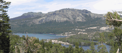
The photo to the right is Silver Lake, Amador County, California. It's about a 38 miles from our weather station location in Placerville. There are also complete sets of Hurricane observation radar on the Forecast page.
|
The Purpose & Site Summary
Although this site features the City of Placerville and El Dorado County, my overall vision and goal for this site is to offer all the weather tools, maps, and radar needed for any one living in the United States to enjoy. People differ in their likes and dis-likes of online weather satellites, radars, maps and tools. So I tried to give a nice variety of all of these weather tools.
I provide weather coverage for most anywhere in the world. Some of the world known sites I provide weather data to are, NOAA (The National Weather Service), CWOP (Citizens Weather Observation Program), APRS (Automatic Position Reporting System), Weather Underground, Homeland Security, Weather For You, Ham Weather, and several other weather related services which are listed below.
This site is still very young, it launched at the end of June 2006. It is continuously being improved upon as I work on it several hours a week. It still has quite a bit left to be done. In the mean time I hope you find the site useful for your weather needs. I am always open for comment and sugestions and would value your input. Email me from -
El Dorado Weather
|
|
|
|


