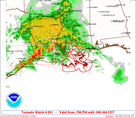
WW 251 TORNADO LA CW 170055Z - 170800Z
URGENT - IMMEDIATE BROADCAST REQUESTED
Tornado Watch Number 251
NWS Storm Prediction Center Norman OK
755 PM CDT Thu May 16 2024

The NWS Storm Prediction Center has issued a

* Tornado Watch for portions of
  Southeast Louisiana
  Coastal Waters

* Effective this Thursday night and Friday morning from 755 PM
  until 300 AM CDT.

* Primary threats include...
  A couple tornadoes possible
  Scattered damaging winds and isolated significant gusts to 75
    mph possible
  Isolated large hail events to 1.5 inches in diameter possible

SUMMARY...A broken squall line will move east into southeast
Louisiana this evening and progress east across the Watch area
tonight.  In addition to the risk for a couple of tornadoes, severe
gusts (60-75 mph) capable of wind damage may accompany the more
intense portions of the squall line.

The tornado watch area is approximately along and 65 statute miles
north and south of a line from 5 miles north of Lafayette LA to 35
miles east of Boothville LA. For a complete depiction of the watch
see the associated watch outline update (WOUS64 KWNS WOU1).

PRECAUTIONARY/PREPAREDNESS ACTIONS...

REMEMBER...A Tornado Watch means conditions are favorable for
tornadoes and severe thunderstorms in and close to the watch
area. Persons in these areas should be on the lookout for
threatening weather conditions and listen for later statements
and possible warnings.

&&

OTHER WATCH INFORMATION...CONTINUE...WW 249...WW 250...

AVIATION...Tornadoes and a few severe thunderstorms with hail
surface and aloft to 1.5 inches. Extreme turbulence and surface wind
gusts to 65 knots. A few cumulonimbi with maximum tops to 500. Mean
storm motion vector 27035.

...Smith
WW 250 SEVERE TSTM NM TX 162000Z - 170400Z
URGENT - IMMEDIATE BROADCAST REQUESTED
Severe Thunderstorm Watch Number 250
NWS Storm Prediction Center Norman OK
300 PM CDT Thu May 16 2024

The NWS Storm Prediction Center has issued a

* Severe Thunderstorm Watch for portions of
  Southeast New Mexico
  West Texas into the Edwards Plateau

* Effective this Thursday afternoon and evening from 300 PM until
  1100 PM CDT.

* Primary threats include...
  Scattered large hail and isolated very large hail events to 2
    inches in diameter possible
  Scattered damaging wind gusts to 70 mph possible

SUMMARY...Thunderstorms will increase in coverage and intensity
through the afternoon/evening while spreading from southeast New
Mexico into west Texas and the Edwards Plateau.  The main threats
will be large hail up to 2 inches in diameter with the more discrete
supercells, while severe outflow winds of 60-70 mph will be possible
as storms grow upscale into one or more line segments.

The severe thunderstorm watch area is approximately along and 60
statute miles north and south of a line from 60 miles west southwest
of Hobbs NM to 60 miles northeast of Junction TX. For a complete
depiction of the watch see the associated watch outline update
(WOUS64 KWNS WOU0).

PRECAUTIONARY/PREPAREDNESS ACTIONS...

REMEMBER...A Severe Thunderstorm Watch means conditions are
favorable for severe thunderstorms in and close to the watch area.
Persons in these areas should be on the lookout for threatening
weather conditions and listen for later statements and possible
warnings. Severe thunderstorms can and occasionally do produce
tornadoes.

&&

OTHER WATCH INFORMATION...CONTINUE...WW 248...WW 249...

AVIATION...A few severe thunderstorms with hail surface and aloft to
2 inches. Extreme turbulence and surface wind gusts to 60 knots. A
few cumulonimbi with maximum tops to 500. Mean storm motion vector
29025.

...Thompson
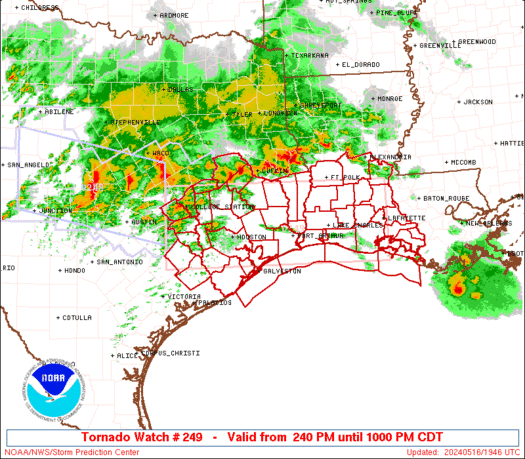
WW 249 TORNADO LA TX CW 161940Z - 170300Z
URGENT - IMMEDIATE BROADCAST REQUESTED
Tornado Watch Number 249
NWS Storm Prediction Center Norman OK
240 PM CDT Thu May 16 2024

The NWS Storm Prediction Center has issued a

* Tornado Watch for portions of
  Southwest Louisiana
  Southeast Texas
  Coastal Waters

* Effective this Thursday afternoon and evening from 240 PM until
  1000 PM CDT.

* Primary threats include...
  A couple tornadoes possible
  Scattered damaging wind gusts to 70 mph likely
  Scattered large hail and isolated very large hail events to 2
    inches in diameter possible

SUMMARY...Clusters of storms will continue to develop and spread
east-southeastward through early tonight along a composite outflow
boundary sagging southward across east Texas.  The potential for
supercells with large hail of 1-2 inches in diameter and a couple of
tornadoes will increase with new storm development south of the
outflow.  Otherwise, embedded supercells and bowing segments will
pose a threat for damaging winds of 60-70 mph, as well as a couple
of tornadoes with embedded circulations.

The tornado watch area is approximately along and 55 statute miles
north and south of a line from 40 miles southwest of College Station
TX to 5 miles east southeast of Lafayette LA. For a complete
depiction of the watch see the associated watch outline update
(WOUS64 KWNS WOU9).

PRECAUTIONARY/PREPAREDNESS ACTIONS...

REMEMBER...A Tornado Watch means conditions are favorable for
tornadoes and severe thunderstorms in and close to the watch
area. Persons in these areas should be on the lookout for
threatening weather conditions and listen for later statements
and possible warnings.

&&

OTHER WATCH INFORMATION...CONTINUE...WW 248...

AVIATION...Tornadoes and a few severe thunderstorms with hail
surface and aloft to 2 inches. Extreme turbulence and surface wind
gusts to 60 knots. A few cumulonimbi with maximum tops to 600. Mean
storm motion vector 28030.

...Thompson
WW 0251 Status Updates
STATUS FOR WATCH 0251 HAS NOT BEEN ISSUED YET
WW 0250 Status Updates
STATUS REPORT ON WW 250

SEVERE WEATHER THREAT CONTINUES RIGHT OF A LINE FROM 60 NNE 6R6
TO 60 W SJT TO 45 WNW SJT TO 30 SE BGS TO 20 ESE BGS TO 30 ENE
BGS TO 50 NE BGS.

FOR ADDITIONAL INFORMATION SEE MESOSCALE DISCUSSION 0809

..BENTLEY..05/17/24

ATTN...WFO...MAF...SJT...LUB...


STATUS REPORT FOR WS 250

SEVERE WEATHER THREAT CONTINUES FOR THE FOLLOWING AREAS

TXC049-059-081-083-095-105-151-235-267-307-319-327-335-353-383-
399-411-413-415-431-435-441-451-170240-

TX
.    TEXAS COUNTIES INCLUDED ARE

BROWN                CALLAHAN            COKE
COLEMAN              CONCHO              CROCKETT
FISHER               IRION               KIMBLE
MCCULLOCH            MASON               MENARD
MITCHELL             NOLAN               REAGAN
RUNNELS              SAN SABA            SCHLEICHER
SCURRY               STERLING            SUTTON
TAYLOR               TOM GREEN


THE WATCH STATUS MESSAGE IS FOR GUIDANCE PURPOSES ONLY.  PLEASE
REFER TO WATCH COUNTY NOTIFICATION STATEMENTS FOR OFFICIAL
INFORMATION ON COUNTIES...INDEPENDENT CITIES AND MARINE ZONES
CLEARED FROM SEVERE THUNDERSTORM AND TORNADO WATCHES.
WW 0249 Status Updates
STATUS REPORT ON WW 249

SEVERE WEATHER THREAT CONTINUES RIGHT OF A LINE FROM 5 NE GLS TO
20 NE LCH TO 15 ESE POE.

..SPC..05/17/24

ATTN...WFO...LCH...HGX...


STATUS REPORT FOR WT 249

SEVERE WEATHER THREAT CONTINUES FOR THE FOLLOWING AREAS

LAC001-003-019-023-039-045-053-055-097-099-101-113-170240-

LA
.    LOUISIANA PARISHES INCLUDED ARE

ACADIA               ALLEN               CALCASIEU
CAMERON              EVANGELINE          IBERIA
JEFFERSON DAVIS      LAFAYETTE           ST. LANDRY
ST. MARTIN           ST. MARY            VERMILION


TXC039-071-167-245-170240-

TX
.    TEXAS COUNTIES INCLUDED ARE

BRAZORIA             CHAMBERS            GALVESTON
JEFFERSON


GMZ335-355-430-432-435-436-450-452-455-170240-

CW

.    ADJACENT COASTAL WATERS INCLUDED ARE
MD 0809 CONCERNING SEVERE THUNDERSTORM WATCH 250... FOR THE PERMIAN BASIN INTO CENTRAL TEXAS
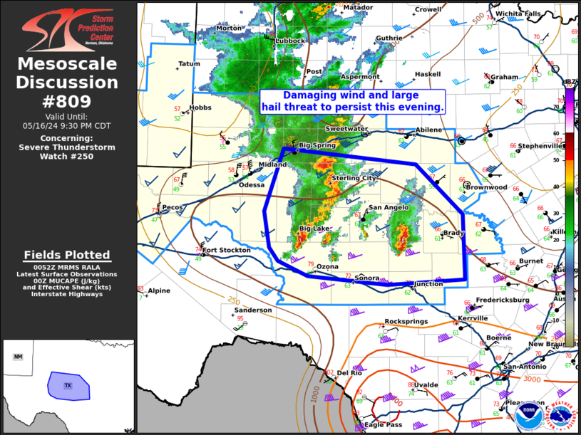
Mesoscale Discussion 0809
NWS Storm Prediction Center Norman OK
0754 PM CDT Thu May 16 2024

Areas affected...the Permian Basin into central Texas

Concerning...Severe Thunderstorm Watch 250...

Valid 170054Z - 170230Z

The severe weather threat for Severe Thunderstorm Watch 250
continues.

SUMMARY...The damaging wind and large hail threat will persist this
evening.

DISCUSSION...A well formed line of storms which produced significant
wind damage in parts of Midland has grown upscale as it continues to
accelerate east. This will continue to pose a threat for 70 to 80
mph wind gusts as it moves east. Ahead of this line, a strong
supercell which has a history of 2.75 to 3 inch hail continues to
move east. This supercell and the squall line are both moving toward
better instability. Additional cells are forming between the squall
line and the mature supercell, but it is still uncertain if any
additional well established supercells can develop. Given the more
favorable downstream environment and the synoptic support from the
upper-level wave, expect the threat from the squall line and any
leading supercells to continue for at least a few more hours.

..Bentley.. 05/17/2024

...Please see www.spc.noaa.gov for graphic product...

ATTN...WFO...SJT...MAF...

LAT...LON   31000187 31470196 32270167 32079971 31439902 30599899
            30530014 30650131 30840174 31000187
MD 0808 CONCERNING TORNADO WATCH 249... FOR UPPER TX COAST...SOUTHERN LA
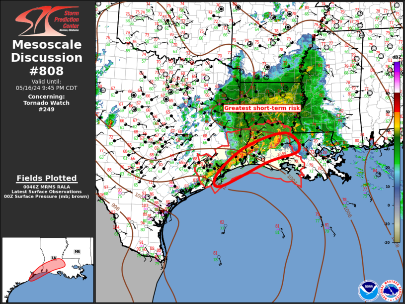
Mesoscale Discussion 0808
NWS Storm Prediction Center Norman OK
0749 PM CDT Thu May 16 2024

Areas affected...Upper TX Coast...Southern LA

Concerning...Tornado Watch 249...

Valid 170049Z - 170245Z

The severe weather threat for Tornado Watch 249 continues.

SUMMARY...Severe threat will spread across the remaining
southeastern portions of ww249 this evening. Damaging winds, and
perhaps a tornado or two, remain the primary risks.

DISCUSSION...Large MCS has matured over northern LA/upper TX Coast
and is propagating downstream toward the lower MS Valley. Latest
radar data suggests an MCV may be forming within the expansive
precip shield over the lower Sabine River Valley. This feature is
moving east and may contribute to the overall organization of the
cluster as it spreads across southern LA. LLJ is forecast to
strengthen across southern LA over the next few hours and latest VAD
from LCH supports this with 0-3km SRH in excess of 550 m2/s2. Strong
low-level warm advection favors a well-organized MCS advancing east
and damaging winds remain the greatest risk along the surging
bow-like structures. Additionally, some tornado risk continues with
embedded supercells along the QLCS.

..Darrow.. 05/17/2024

...Please see www.spc.noaa.gov for graphic product...

ATTN...WFO...LIX...LCH...HGX...

LAT...LON   29359506 30449379 31009194 30309133 29849277 28889487
            29359506
SPC 0100Z Day 1 Outlook

Day 1 Convective Outlook
NWS Storm Prediction Center Norman OK
0746 PM CDT Thu May 16 2024

Valid 170100Z - 171200Z

...THERE IS A SLIGHT RISK OF SEVERE THUNDERSTORMS THIS EVENING INTO
TONIGHT ACROSS PARTS OF THE TEXAS EDWARDS PLATEAU...THE UPPER TEXAS
COAST AND SOUTHERN LOUISIANA...

...SUMMARY...
An organized cluster of storms may pose a continuing risk for severe
wind gusts across parts of southern Louisiana through late evening.

...01Z Update...
A large, modestly organized cluster of storms is in the process of
propagating east-southeastward across upper Texas coastal areas and
southwestern Louisiana.  Ahead of this activity, inland of the
Louisiana coast, notable boundary-layer layer cooling has already
occurred (4-8+ degrees the past 3 hours), beneath relatively warm
layers evident in the lower/mid-troposphere in the 00Z soundings
(e.g. Lake Charles).  However, it is still possible that low-level
moistening off the Gulf of Mexico, coincident with strengthening
south to southwesterly flow (30-50+ kt) in the 850-700 layer, may
contribute to a continuing severe wind risk with the convective
cluster across at least southern portions of Louisiana through mid
to late evening.

In the wake of the prominent lead convective cluster, outflow has
contributed to substantial stabilization of the low-level
environment across much of central Texas toward upper/middle Texas
coastal areas and Deep South Texas.  Models suggest little
appreciable modification this evening, with further southward and
southwestward progression of the outflow boundary into Deep South
Texas and the Rio Grande Valley.  As strong to severe convection now
spreading across the Edwards Plateau vicinity encounters this
environment during the next few hours, it seems likely to weaken.

..Kerr.. 05/17/2024
SPC Day 3-8 Fire Weather Outlook

Day 3-8 Fire Weather Outlook
NWS Storm Prediction Center Norman OK
0530 PM CDT Thu May 16 2024

Valid 181200Z - 241200Z

By early this weekend a broad, longwave trough is expected over the
far northern/northwestern CONUS with a subtropical jet continuing to
progress east-northeastward from the Gulf Coast into the Carolinas.
The mid to upper flow will then begin to amplify a bit late this
weekend into next week as an upper trough digs into the Great Basin
and a southern stream shortwave trough approaches southern
California. Stronger southwest flow aloft will begin to develop
across much of the western half of the CONUS as this occurs,
especially by D5/Monday from the northern Baja Peninsula into the
central and southern High Plains. As the week progresses, the upper
trough will traverse the Plains Tuesday and the eastern half of
CONUS by D7/Wednesday. Shortwave ridging will follow it over the
Plains as a north Pacific upper low digs a bit into the Great Basin.
Modest quasi-zonal flow will encompass most of the southern CONUS by
D8/Thursday.

  ...Southwest and Southern High Plains...
Increasing west to southwest surface winds are expected across New
Mexico and the High Plains D3/Saturday as a lee surface trough
slowly begins to deepen in response to increasing orthogonal mid
level flow across the southern Rockies. Some locally elevated fire
weather conditions will likely develop on D3/Saturday across
portions of northern Arizona where fine fuels receiving little to
zero appreciable rainfall will be drier, but limited area-wide
receptive fuels will preclude an introduction of higher
probabilities. Increasing sustained surface wind speeds will begin
to develop across the Oklahoma/Texas panhandles through southeast
New Mexico and West Texas D4/Sunday afternoon. Mid-level
southwesterlies will continue to increase D4-D5 Monday/Tuesday from
the Desert Southwest across the southern and central Rockies,
promoting continued sustained surface wind speeds across southern
New Mexico and portions of west Texas ahead of a cold front moving
into the Texas panhandle. Fuels will continue to cure across New
Mexico, central and southern Arizona through the end of the week
where appreciable precipitation is not anticipated, although
elevated surface wind speeds will likely remained confined to
southwestern New Mexico D7/Wednesday. By D8/Thursday, however, more
widespread 15 to 20 mph sustained speeds are expected to develop
across much of New Mexico again where RH below 15% will be present.

..Barnes/Nauslar.. 05/16/2024

...Please see www.spc.noaa.gov/fire for graphic product...
|